mappt – yes a promotional piece but maybe some thought is mixed into it

How many times have you opened up Microsoft Word and tried to find that one function that is hidden away? It has happened to us all, we waste time ages trying to find the function only to end up opening ‘Help’ and reading through the instructions. Due to the evolution of core spatial software, the same can now be said for a myriad of GIS applications, with functions galore and an interface that would scare off even some of the most tech savvy professionals out there.

Welcome to the world of apps. Small, dedicated and smart applications are now available as either add-ons or dedicated pieces of software that are used on mobile devices. Example; ‘Twitter’, a simple application to post short messages. It has some value add functions for capturing photos adding links  etc., however the premise is simple: post a message in 140 characters or less.

The simple application that meets the core needs of a user is a different mindset to what we have traditionally expected. Evaluating software based on the number of features it supports is tried and tested although not all features may be required. Changing habits and technology required vendors to think about the software they develop. Not so long ago the mobile space was commanded by ArcPad Mobile and whatever else worked on WindowsX based platforms. This is rapidly changing.

The advent of tablet technology is enabling people to work when and where they want and the hardware supporting these gadgets are almost as good as any desktop device. Last I looked, an OctaCore tablet supporting a 32 GB memory and a screen resolution that makes your eyes boggle for only $500 invites you to leave the office and work in the field with your data.

The issue I find, is that while habits are changing and allowing us to work where we want, the applications in the spatial field are still focused on functions and features without too much thought on design and need. Simple workflow supporting core functions is not too far fetched is it?

Recently I have been privileged to help a start-up company whom have taken a design focus to its mapping application. Introducing ‘Mappt’ (only on Android)mappt-logo-med is one of the different breed of technical applications now designed for specific workflows. Its focus is not to be the king of mobile GIS applications, but fit in with a modern workflow where quick and agile use while working in a disconnected environment is needed. In essence, they have looked at a workflow and engineered a product for a specific component.

Its marketplace, ArcGIS for Mobile, GIS2Go, WolfGIS and iGIS (for the iOS), plus others all contain a range of features similar and equivalent to Mappt. Some require ongoing subscription plans, others require a supported backend enterprise  but the premise is the same. Field base GIS work traditionally uses pen/paper/printed maps and technology and new data capture done on laptops or by drawings. Tablets provide flexibility to capture and manage data in a structure that is familiar to you when in the office. Applications should be focused on allowing the professionals to manage the data flow, while others are empowered to capture it while in the field.

                              gis2go        esri      wolfgis

While the spatial industry will no doubt always be a technically focused industry, these smaller, more focused applications are now empowering others to deliver the base level of information needed for businesses. Collecting, adding to and sharing data from field to office can now easily be outsourced to many through these types of applications. Where will we find ourselves in five years time is anyone’s guess, but at this rate I propose that the professional skills many of us studied over a number of years will be best put to quality assurance, rather than core spatial information capture.


Has it been two months and I’ve missed an election?

What a busy two months it has been, an election, almost a result, the launch of new and exciting products, location based marketing making it to the main stream (see Gruen Transfer Season 3 Episode 8: http://www.abc.net.au/tv/gruentransfer/watch.htm)

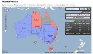
As I missed updating throughout the 2010 election (although who knows, another might be coming up?) I wondered where all the election promises and spend would be most affected. An interesting mashup indeed but alas I could not find one. The best use of spatial data covering the election that I could find came from our good friends at the ABC with a little help of Google Maps. The ABC Interactive Map (http://www.abc.net.au/elections/federal/2010/map/) really made it easy to keep track of how each electoral seat is currently fairing. It is a fantastic mix of AEC data, address verification, modelling and presentation.

Other interesting sites were the Tally Room (http://www.tallyroom.com.au/election-2010) and of course our good friends at NuMaps (http://demos.numaps.com.au/myElectorate.html). These sites have done a good job of linking to one another and while on the Tally Room I got stuck on opening up many KML links to Google Earth for Australia and other countries. Who would have thought politics was so interesting?

NuMaps is increasingly becoming the source of truth for heaps of demographic information (that just happens to be location aware). So successful has been the Google/NuMaps integration that it recently won the Apps4NSW mash-up competition.

Yet, with these useful and insightful mashups I yet to find one that pinpoints exactly where each election promise will be affected and where the money is going. I’m sure a powerful map highlighting this information would be a powerful tool indeed.

Still, while the election draws out I can only wonder how the next generation of politicians will be interacting with their constituents. Surely with the rise of popular social mediums and interactivity what will our expectations be? Log an issue online, pinpoint it to a map (location) and wait for the politician to respond? I’ve seen more targeted pitches to win voters and so is the next step personalised pitches based on location? Time will only tell.

Urban Planning in the 21st Century

Over the last few months the new CRC-SI 2 has been kicking into motion and positioning itself for the research areas the new program will be looking to achieve. For those who have been involved no doubt you are aware of the history of the CRCSI but for those who are not up on the current lingo, the CRCSI is short for the Cooperative Research Centre for Spatial Information and ‘2’ is the second round of funding that the organisation has received from the federal government.

With this second round of funding the CRCSI will be able to work for the next seven years around the theme of Spatially Enabling Australia. The core research areas are Positioning, Automated Spatial Information Generation and Spatial Infrastructures. See this handout for more information.

As part of the CRCSI 2 work programs there are a number of application areas that will also be looked into and one has stuck my interest. The Sustainable Urban Planning (program 4.5 pdf: here) organisers recently held a seminar on the subject of Greyfields.

Greyfields are the ageing occupied residential tracts of suburbs that are physically, technologically and environmentally obsolescent……..typically found in a 5 to 25 kilometre radius of the centre of each capital city”‘ Professor Peter Newton.

With population growth, affordable housing and increase need for better government spending the rejuvenation of these areas of urban living must be proving a great challenge. What I feel will be key for this research theme is the engagement of community on urban planning as it was highlighted that within ‘greyfields’ most of the land is under private ownership. This proves an interesting sticky point for redevelopment in light of current issues.

As housing affordability and population growth are hot topics and that urban sprawl is becoming more and more unsustainable the greyfields are key to helping address these problems. In another session I attended recently titled ‘Boom Town 2050’ it was highlighted that the density of dwellings in Australia is not at the levels it needs to be to support population growth. Hopefully with research, engagement with community and importantly action the use of spatial within this area will be seen as critical to realising and communicating what needs to be done.

GSDI 12 – Embracing Social Media

For those who are into Spatial Data Infrastructures you are know doubt aware of GSDI 12 (Global Spatial Data Infrastructure Association) which is occurring in Singapore later this year. This conference is the 12th running and is themed ‘Realising Spatial Enabled Societies’ and I highly recommend attending as with the growth of social media, societies seem only one (large) step away from fully realising the benefits of location/spatial in day to day operations.

It is with great interest on the promotion of this even that the organisers have embraced twitter (@GSDI12) and is even using You Tube as a means to market what is happening for GSDI. As a twitter user I have been following the thread with great interest and glad to see that the updates come thick and fast throughout the weeks and are not intermittent. This keeps it fresh in my mind and even leads me to blogging about it.

Usage of social media as a means of business marketing in my mind I feel is underutilised in Australia. A statistic that I came across this morning is that 75% of SME do not use social media to advertise their business, (http://bit.ly/dynJtA) yet I find the potential to connect people to place via these mediums allows marketing spend to be targeted to those demographics businesses want to attract. It is with this last thought that I sit back and reflect on the importance of spatial/location. Yes as an industry we realise the importance on adding location as a tag into all data types although listening to a colleague yesterday, if we want to realise a spatially enabled society we need to draw out the benefits to those outside of our industry in a simple, clear way. When comparing adding location tags to data against other tags such as gender, age, nationality, what takes precedence in determining where our limited resources in data collection go?

Technology is enabling the embedding of location to become simpler. Simple user interfaces, better data infrastructures and enabling technologies to bond data between the business and the user is happening. Data infrastructures built on spatial technologies could become a key enabler for social media to expand out from current mass media and advertising markets. Imagine collecting bird sightings through a social media page rather than separate websites to track where endangered species are located in order to facilitate discussion on urban planning. Social media pages such as facebook currently get more ‘visits’ than the Google home page. In planning data infrastructure the time is right to ensure that the information being linked can also link to social media in order to enable the innovative use of data within these sites.

We are good at linking data and we need to get better at linking into current trends and enabling better evidence to be used online. I’m sure there will be many discussions in this space at GSDI 12. I look forward to seeing you there.